The first step in any construction project is to conduct a topographic survey of the area and draw the Layout, Longitudinal Section and Cross Sections. Next is to calculate the quantity of material(earth) required to level the surface for construction.
Using Total Station:
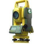
Total station machine is convenient and time-saving for use in survey. It’s especially useful to quickly generate cross section of roads and canals right after survey readings have been transferred to a computer.
LXQ-CAD reads raw UTM format files and converts them to Chainage, Offset, Level format required by the software. Use the Tools>>Convert TS Levels… menu option. After conversion check the initial levels data sheet for the newly added readings.
Only requirement is : mark center/alignment points separately during survey in the remarks. The software determines left or right points based on center point of current chainage.
Total Station machines deliver high accuracy and convenience in surveying a large piece of land. The output of Total Station machines can be directly pasted into LXQ-CAD software in RAW format. The RAW format is machine independent and nearly all TS machines support this format.
Using Auto level:
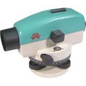
Auto level machines are easy to use, cheaper and reasonably accurate machines for most survey requirements. They are very popular and require less maintenance. Survey conducted using an Autolevel machine requires noting of the levels manually in a Field book. Also, a plan of the site must be created by manual means.
LXQ-CAD software includes a converter module to convert the Field Book data into the Chainage-Offset-Reduced Level format supported by the software.